Embark On An Enchanting Journey To Gaumukh In Uttarakhand
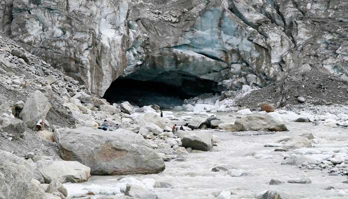
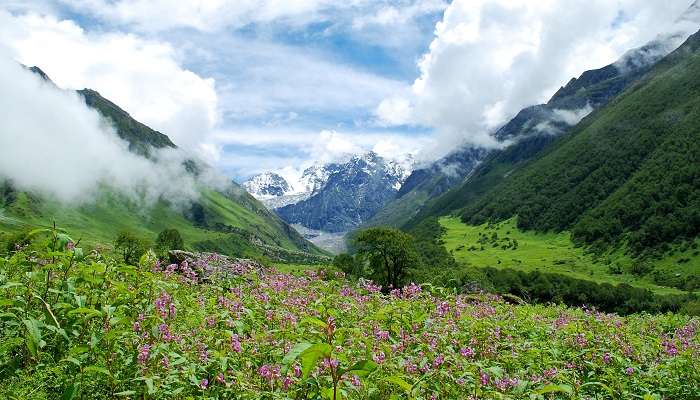
Gaumukh also known as Gomukh or Gomukhi is the terminal point or the snout of the Gangotri Glacier situated in the district of Uttarkashi of the Indian State of Uttarakhand. Located at an altitude of 13,200 feet (4,023 meters), Gaumukh is held in high regard as it is the source of the Bhagirathi River which later forms the Ganga River. Gaumukh implies ‘Gau’ which is cow and ‘Mukh’ is the mouth, therefore literally the name means the mouth of a cow because of its appearance that looks like a cow’s mouth. Gaumukh is not only an important religious place for Hindus but also an ideal spot for trekking with stunning views of the snowy Himalayas and the great Gangotri Glacier.
Gaumukh: The Sacred Source Of The Ganga River
Gaumukh is considered sacred in Hinduism, as a holy site of worship and pilgrimage. In Hindu religious texts, it is even mentioned that the goddess Ganga descended from the ‘heaven’ at this place at the insistence of King Bhagirath who was determined to cleanse the souls of his ancestors of their sins. This sacred origin makes Gaumukh a worshipped religious destination, with a number of devotees visiting the place coming from India and other various parts of the world. The pilgrimage to Gaumukh has been an arduous journey of faith for many, carrying both physical and religious significance over centuries.
Must Read: Things To Do In Gangotri
The Gaumukh Trek
Gaumukh trek is a strenuous 18 km trek from Gangotri to Gomukh including a further 5 km to Tapovan if interested. The difficulty of the terrain ranges from moderate to steep, which makes it ideal for amateur hikers and professional trekkers.
Gangotri To Chirbasa
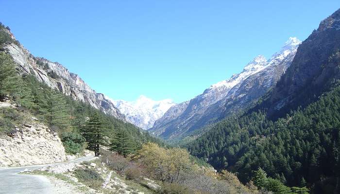
The trek starts from Gangotri, which is a small town and the first place in the pilgrimage. From Gangotri, the route to Gaumukh is through a thick forest of pine trees and as one advances the area becomes relatively more barren. The first part of the trek is from Gangotri to Chirbasa, which is nearly 9 km away from Gangotri. The difficulty of this part of the journey is mild, and this serves to prepare one for the major challenges that follow in the next parts of this journey. Trekkers get spectacular views of the Bhagirathi peaks and might even spot some Bharals which are otherwise known as mountain antelopes.
Suggested Read: Guccupani Robber’s Cave
Chirbasa To Bhojbasa
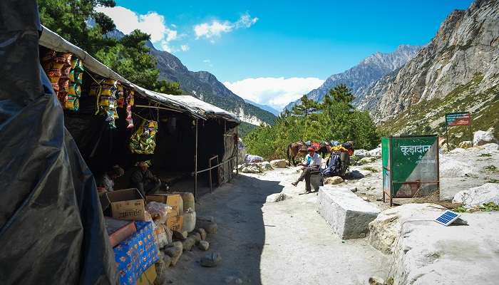
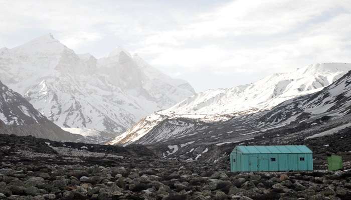
The path further leads to Bhojbasa, located 5 kilometres from Chirbasa in the next direction. With the increase of altitude, it is observed that the vegetation cover becomes scarce and there are more rocks in the region. This section is relatively difficult but comes with stunning cliffs providing spectacular views of the nearby mountains. Bhojbasa is the last point for mountain accommodation and is at an altitude of 3,800 meters with GMVN guest houses and ashrams. The trekkers enjoy a relaxing evening in the picturesque Bhojbasa, which offers stunning sunset scenes before darkness overtakes the area.
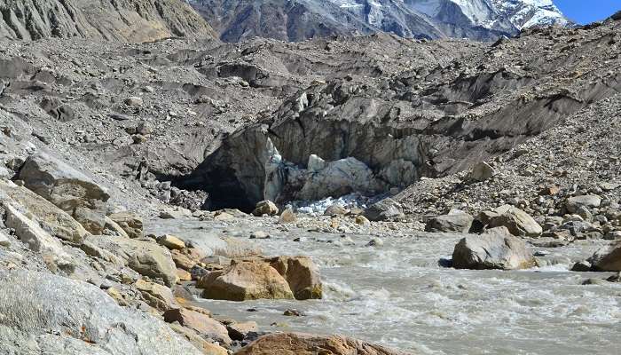
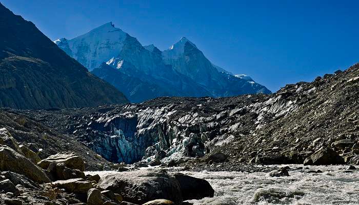
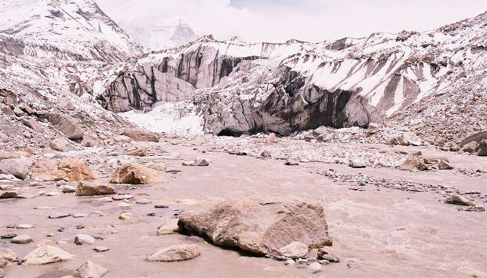
Bhojbasa To Gaumukh
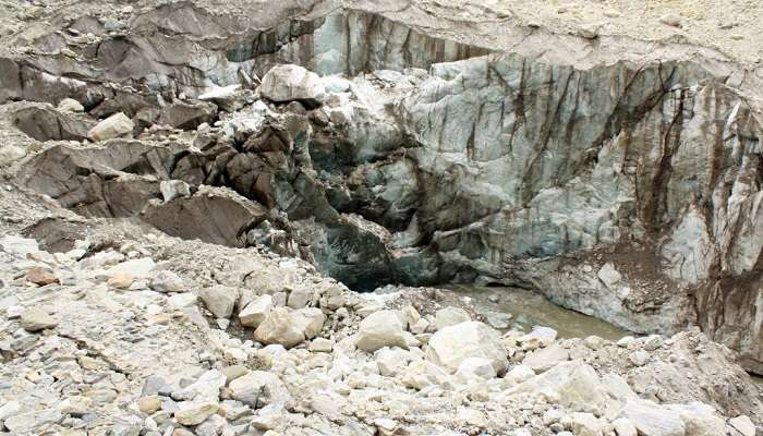
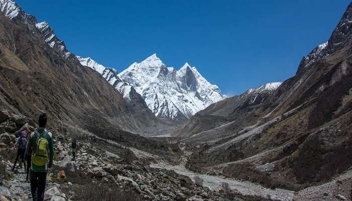
The last part of the trek up to Gaumukh from Bhojbasa is a 4-Kms trek on a steep trail through boulders and rocks at most places. This part of the trek is most challenging but offers the glorious sight of Mount Shivling and the Bhagirathi group of peaks. When trekkers reach Gaumukh, they are stunned by the divinity of the place as well as the natural beauty of the glacier. The view of the glaciers, particularly the most prominent snout from where the Bhagirathi River originates, is spiritually moving to many.
Suggested Read: Places To Visit In Gangotri
Optional Extension to Tapovan
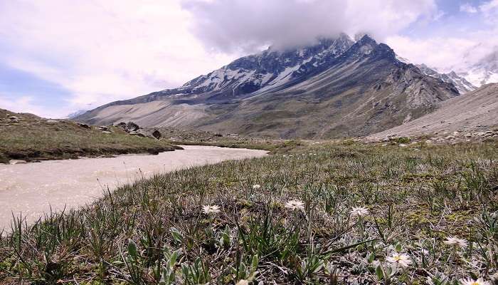
If one wants to go further, one may have to go up to Tapovan, which is an extra five kilometres beyond Gaumukh. The Gaumukh Tapovan trek trail is quite challenging with steep slopes and is recommended to hire a guide for safety. But all this effort is well worth it because Tapovan is famous for the high-altitude grassy pastures, streams, and vistas of the great Himalayan range. It is a great place for any trekker who is looking for a little isolation and stunning views of the mountains.
Climatic Conditions In Gaumukh
The temperature of Gaumukh changes with the different seasons. Spring is relatively mild with moist and warm conditions during the day, which is between 10°C and 15°C, though the night is freezing. During the summer, the temperature during the day reaches 20 degrees Celsius, although nights remain cool. Autumn is warm and dry with clear skies. The temperatures range between 10 and 15 Celsius during the day but drop drastically at night. In winter, the climate is quite severe with heavy snow cover, which makes the path impassable.
Suggested Read: Places To Visit In Uttarakhand
Food Availability And Mobile Connectivity
The food available on the Gaumukh trek is very limited and one can only expect basic meals and snacks from the guest houses and ashrams available at Gangotri and Bhojbasa. Food served to trekkers is usually very basic vegetarian meals normally consisting of rice, lentil, vegetables and chapatis. For the trek, it is recommended that you carry along with you some energy-dense foods such as nuts, dried fruits, and energy bars.
Mobile signal is weak along the trekking route and non-existent in Gaumukh. There is poor BSNL connection available at Gangotri and as you move towards Gaumukh there is no network connectivity at all. It’s optimal to let your close ones know about the low chances of communication before embarking on the trek.
Best Time To Visit
The best time to pay a visit to Gaumukh is during the season of spring which is from mid-April to June and the autumn season which is between September to early November. These climatic conditions favour the hike since temperatures and weather conditions are relatively cool with clear skies. It is probably better to avoid travelling during the monsoon which starts in the middle of July and ends in August due to flooded roads and frequent landslides. The Gangotri region is closed for tourists from late November to March every year due to heavy snowfall.
Suggested Read: Gangotri Glacier Trek
Ways To Reach Gangotri
By Road: Gangotri is about 300 km from Dehradun and will take approximately 8 hours to reach by road.
By Train: The nearest railway station is Rishikesh which is 234 km away from Gangotri.
By Air: The closest airport is Jolly Grant Airport, Dehradun which is approximately 250 km away from Gangotri.
Tips And Suggestions
Footwear: Sports shoes may suffice, but it is advised to wear trekking shoes that have a strong grip and can offer good ankle support to ensure comfort and stability.
Clothing: Always ensure you carry a warm jacket even if you are travelling during summer because the weather changes are unpredictable and you might find it extremely cold and windy especially when trekking.
Permits: The permit for Gaumukh can be easily obtained by fax.
Gila Pahar: It may, therefore, be advisable to be careful at the “Gila Pahar” area which is roughly 3 kilometres from Chirbasa due to recurrent landslide incidents.
Route Difficulty: It is important to understand that after Bhojbasa, the trail becomes more demanding, especially after the floods in 2013.
Monsoon Season: Trekking should not be done when it is raining, specifically during the monsoon season because of slippery tracks, frequent occurrences of landslides and occasional cloudbursts.
Group Trekking: In most cases, trekking alone is discouraged. It is always wise to hike in groups of two or more and to plan to be back by a certain time.
Provisions: Ensure that you take enough snacks for you during the journey such as dry fruits, chocolates and adequate water for drinking.
Intoxicants: Do not take alcoholic beverages or any other substances during the trek that may lead to intoxication.
Night Trekking: One should not embark on a trek during the night for security concerns.
Medical Consultation: It is highly recommended that anyone with a chronic illness or disability should consult with a doctor before attempting the trek.
Medications and First Aid: Take essential medicines for fever, headache, stomach upset, body pain, and a first aid kit.
Littering: As a responsible trekker, do not litter around this place and keep it clean. If you are carrying polythene bags, ensure that you do not drop them around but take them back with you in an effort to ensure the environment is maintained clean.
Essential Gear: Other necessary items that are also recommended include trekking poles, a sleeping bag and mat if one plans on camping, sunscreen of high SPF, sunglasses, a hat or cap, a first aid kit, and a headlamp or flashlight.
Further Read: Places To Visit In Uttarkashi
A trip to Uttarakhand and to Gaumukh especially is not just tourism but it is a voyage to one of the holiest abodes, an exciting expedition through the Himalayan land and communion with the beauty of nature in its purest form. Uttarakhand, referred to as ‘Dev Bhoomi’ or the ‘Land of the Gods’, is not just magnificent and majestic but also calming and liberating. Gaumukh which is the snout of the Gangotri Glacier and the source of the river Ganga is revered in Hindu Mythology and well-known amongst pilgrims and trekkers.
For our editorial codes of conduct and copyright disclaimer, please click here.
Cover Image Credit: Barry Silver for Wikimedia Commons
Frequently Asked Questions About Gaumukh
What is Gaumukh, and why is it significant?
Gaumukh located in the Tehri Garhwal district of Uttarkashi, in the state of Uttarakhand at 13,200 feet is the terminal point of Gangotri Glacier and the origin of the river Bhagirathi which later transforms into River Ganga. Called after the shape of a cow’s mouth, people visit this place due to its religious importance for Hindus and adventurous trekkers planning to climb the Himalayas to get a glimpse of this natural wonder.
When is the best time to visit Gaumukh?
It is suggested to plan the trip to visit Gaumukh from mid-April to June and September to early November. These times offer favourable temperatures as well as good atmospheric conditions for trekking adventures. There are some precautions which one needs to keep in mind while planning to visit Gaumukh, it is not preferable to go in the monsoon season which is mid-July to August because of heavy rains and sometimes landslides. Due to heavy snow, from early November to March, the place remains closed to tourists and visitors.
How can I reach Gaumukh?
The place of Gaumukh can be accessed after reaching the town of Gangotri. From Dehradun, Gangotri is well approachable by road, approximately 300 km and 8 hours journey. The nearest railhead is available at Rishikesh which is 234 km from here and the nearest airport is the Jolly Grant airport at Dehradun, 250km. The total distance of the Gaumukh trek, starting from Gangotri is 18 kilometres.
What are the main trekking routes to Gaumukh?
The distance between Gaumukh and Gangotri is 18 kilometers which can be covered by trekking on foot. After that the ascent of Gangotri, trek about 9 km to Chirbasa through the forest of pine trees with glimpses of Bhagirathi peaks. The next 5 Kms up to Bhojbasa is moderately difficult with some difficulties arising from rocks forming the trails but you get to enjoy excellent views of mountains all around. The last 4 km from Bhojbasa to Gaumukh is a strenuous trek which involves steep climbing on the moraines and provides good view of Mount Shivling and Bhagirathi peaks. Those passionate for more robust and higher altitude terrains can further trek 5 km up to Tapovan which has amplifying meadows and stunning views of the Himalayas.
What should I know about permits and regulations for trekking to Gaumukh?
For trekking to Gaumukh one has to take a permit from the District Forest Officer (DFO) in Uttarkashi. They can be procured from the forest department website or from the forest division offices situated in Uttarkashi or Gangotri district. Permit is limited to only 150 people a day for the conservation of the environment. The permit charges INR 150 for Indian nationals while for foreigners it is INR 600. Moreover, a refundable fine of INR 100 is charged to anyone found with a plastic bag, to be refunded when the bags are returned. Permits are still verified at the entrance of Gangotri National Park at the check post.
People Also Read:
Hotels Near Gangotri Uttarakhand In March Places To Visit In Kasol

With a passion for exploring and travelling to the roads long forgotten, experience the world through enthralling stories and adventures. Join me as I share my experiences at some of the world’s most popular tourist destinations and quench that pestering curiosity with something exciting!